Satellite images taken before and after Hurricane Ida swept through Louisiana this week are showcasing the upsetting extent to which people have suffered without power in New Orleans.
Hurricane Ida, a Category 4 storm, made landfall on August 29 near Port Fourchon, Louisiana. Its winds, at 150 miles per hour (240 km/h), along with torrential rains and storm surges, wreaked havoc across much of Louisiana and Mississippi, downing power lines and destroying transmission towers.
The remnant of Ida caused serious flooding overnight in the U.S. northeast, and the ordeal is far from over in the south. As CBS reports, some people in Louisiana could be without power for three weeks—just as temperatures are set to soar in the coming days. Nearly 900,000 customers in Louisiana and 31,000 customers in Mississippi were without power as of Thursday afternoon, according to PowerOutageUS.

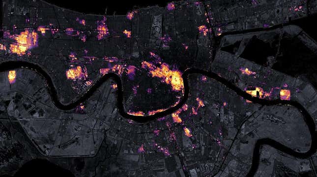
The view from space attests to these figures. Researchers with NASA’s Goddard Space Flight Center and the Universities Space Research Association released before-and-after images of New Orleans, showing the city as it appeared at night on August 9 and August 31. Scientists with the agency’s Black Marble Project processed the images, which included base maps provided by the Landsat 8 satellite.
The images are sobering. New Orleans is typically associated with dazzling lights and vibrant colors, and this dull, gray view of the darkened city is just sad. New Orleans will bounce back—it always does—but Ida is yet another bitter pill this city has to swallow.

The images were taken by the Suomi NPP satellite, which is equipped with the Visible Infrared Imaging Radiometer Suite (VIIRS). The day/night band of this instrument can capture sources of light and also reflections. As NASA’s Earth Observatory explains, VIIRs makes it possible to “distinguish the intensity, types, and sources of lights and to observe how they change.” Importantly, the Black Marble team can filter out sources that aren’t electric lights.
Miguel Román, who leads the Black Marble Project said the new imagery is “capturing a lot of diesel-power/backup generation, which utilities do not monitor,” which is really interesting. Sadly, these generators can only work for as long as there is fuel to power them, and Louisiana is currently facing a gas shortage.
It’ll be a while before we know the full extent to which Ida damaged the United States, but this storm is clearly headed for the history books.
More: New York grinds to a halt as record rain floods city, kills at least 9.