

Apple has announced that its “Look Around” and “Detailed City Experience” features are now available in 20 additional cities including Atlanta, Boston, Chicago, Houston, Miami, London, and Munich. They initially launched in 2021 in San Francisco, London, New York, and LA.
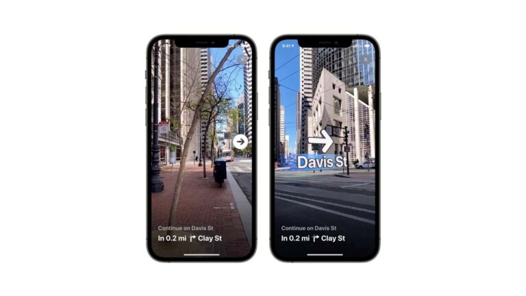
Taking those one at a time, Look Around is Apple’s answer to Google Street View. It includes an AR wayfinding feature to navigate urban areas through directional arrows seen through their upheld smartphone. It’s one of the orbiting parts in Apple’s broader AR master plan.
“Detailed City Experience” meanwhile adds 3D detail to 2D maps. This includes building texture and layers of characteristic colors (think: Golden Gate Bridge) from several angles. The idea is to add dimension to landmarks and sporting venues, and to infuse more local flavor.
With a wider rollout, these features could gain greater traction, while also signaling prime-time readiness. AR wayfinding for example got ample attention when it launched, but has been relatively quiet since. Availability in non-tech hubs could signal a greater mainstream push.
Sensor Fusion
Backing up, Apple Maps’ biggest competitor, Google Maps has long dominated due its adjacency to Google’s search primacy. But Apple has made strides to catch up over the past decade. This follows its stumbles out of the gate with the 2012 “mapgate” botched Apple Maps launch.
These redemption efforts jumped forward with Apple’s 2001 iOS 15 launch. That inflection included the two main 3D features detailed above, which deepen the Maps UX. Apple has also rolled out a string of UX enhancements such as color-coded road navigation and night-time mode.
We saw all these moves coming after Apple began to collect first-party mapping data. That includes Street-View-like imagery and 3D spatial maps. The immediate outcome was Look Around and AR navigation but that could be the tip of the iceberg for Apple Maps’ AR features.
In addition to Look Around’s visual database, Apple can use other data sources to localize AR devices. These include position (via GPS), directional heading (compass), and movement (IMU). Because Apple owns the entire iPhone tech stack, it has sensor fusion on its side.
Long Game
Beyond the iPhone, one question that emerges is how Maps plays into Apple’s headworn AR ambitions. It won’t have a large role in Vision Pro’s indoor use case (except for finding your AirTags). Sleeker AR glasses could align better with mapping… but that’s years away.
Furthermore, it’s not just about AR. Apple’s mapping moves continue to balance utility and sex appeal. For every AR navigation update, there are things like better visual delineations for turn lanes in Maps. For every stylized football stadium, there are navigation modes for safer driving.
Recent updates also include utilities for transit riders, such as clearer station markings and the ability to personalize routes by indicating frequent lines you use. This lets Apple Maps proactively alert users to things like delays, or push notifications to leave home in time to catch your train.
So expect more rapid feature rollouts from Apple Maps. This is what you can expect given the combination of its underdog position and its deep pockets. Throw in its many AR orbiting parts and mapping could be at the center of several converging interests in Cupertino.