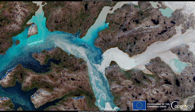
Turquoise, pale grey, and sapphire streaks stand out against a dark taupe, earthen background in a satellite image from the European Union’s Copernicus Earth observation program. It’s a mesmerizing picture, conjuring more immediate associations with a painting than our planet, but it’s not a welcome sight for climate scientists. Instead, the new image illustrates a recent, massive ice melt event in Greenland and the ongoing toll of climate change.
For a few days earlier this month in Greenland, it was hot—really hot, at least for the mostly Arctic landmass. In parts of the country, temperatures hovered around 60 degrees Fahrenheit (15.5 Celsius), more than 10 degrees warmer than the average for July, according to a report from CNN.
Those unusually high temperatures triggered wide-scale snow and ice melt across Greenland’s ice sheet. In just three days, from July 15-17, the landmass lost about 18 billion tons of water. Or, in other terms, enough water to cover the entire state of West Virginia in a foot of water.
Then, the melting intensified even further. Between 8 and 10 billion tons of water per day melted and ran-off from the ice sheet from July 20 to July 23, said Ted Scambos, a glaciologist at the University of Colorado, in an email to Gizmodo. The Copernicus satellite image was captured at the height of that melt event on July 22.
All of that meltwater carried tens of thousands of years of glacial sediment along with it. The opaque, putty colored patches bleeding into the bright blue fjord visible in the satellite image are that sediment (effectively, glacial mud) heading toward the Labrador Sea. Godthåbsfjord, labeled in the image, is known as Nuup Kangerlua in Greenlandic and is located on the Southwestern coast of the country. It’s one of the largest fjord systems in the world, and Greenland’s capital, Nuuk, is located at its mouth.
Since last week, the spike in Greenland’s ice melt has fallen and leveled off closer to what is standard for this time year. However, large melt anomalies remain worrying. In 2021, it rained at the summit of Greenland’s ice sheet for the first time in recorded history. The same month, the landmass lost enough ice in a single day to cover Florida. In 2019, Greenland lost 532 billion tons of ice—the largest amount ever recorded in a single year.
As the country’s ice sheet melts, global sea levels rise, triggering more severe and frequent flooding worldwide. If all of the ice on Greenland were to melt, it would raise sea levels by about 24 feet. But the melting also triggers a feedback loop. As more melt occurs and water pools on the ice sheet surface or leaves exposed rock behind, the landmass becomes less reflective. A less reflective Greenland absorbs more heat and contributes to Arctic warming. So Greenland’s melting ice sheet becomes a self-propelling process.
The Arctic is already warming more than twice as fast as the rest of the planet, and we cannot afford additional losses if we want to stave off the worst impacts of climate change.