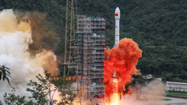
On Tuesday, China launched the final satellite in its BeiDou Navigation Satellite (BDS) System, marking the completion of its homegrown GPS-esque navigation system.
The project has been decades in the making. It began in the 1990s, and the first satellite launch was in October 2000, according to Space.com. BDS is currently one of four global navigations systems. The others are the U.S. government-run GPS, Russia’s GLONASS, and the European Union’s Galileo. While GPS is the most commonly known, you might be familiar with GLONASS or Galileo from various running watches or your car’s navigation system.
The satellite launched Tuesday was the 55th in the BDS system, and the 30th BDS-3 satellite, the most recent version which purportedly has higher bandwidth than its predecessors. For example, the BDS-3 satellites increased short message communication from 120 Chinese characters to 1,200 per message and it can support up to 5 million users, according to the Global Times. In addition to navigation and short message communication, BDS will also enable international search and rescue and more precise point positioning, according to Xinhua News Agency.
Currently, China is working to get BDS ratified by international institutions. So far, it’s expecting the International Civil Aviation Organization to recognize BDS later this year. Meanwhile, the Global Times quotes Yang Changfeng, the chief architect of BDS, as saying the system will be compatible with GPS, GLONASS, and Galileo.
That said, there are political undertones. U.S.-China relations have been strained over a wide range of issues, including 5G adoption, international trade, and the novel coronavirus. By developing its own global navigation system, China is not only reducing its reliance on the U.S.-controlled GPS, but also introducing a system to challenge it. Establishing greater independence from GPS was, in fact, one of the main reasons China decided to develop BDS in the first place, according to Reuters. Reuters also points out that it also helps China keep its military communications secure, while also improving weapons targeting and guidance from a range of 30 cm with GPS, to 10cm in the Asia-Pacific region. It also gives Beijing a degree of military autonomy from the U.S., in the event of any conflict. Completing BDS also potentially signals that China has aspirations to compete with the U.S. with regard to space exploration.
It’s simplistic to say this entire venture is the equivalent of China flipping the U.S. the bird. That said, it is a major sign that China has always been serious about reducing its reliance on U.S. technology—a move that has great geopolitical significance given increased tensions between the two countries over the last few years.