The sun has risen on scenes of widespread destruction from Arkansas to Illinois following a series of deadly tornadoes that hit overnight on Friday.
At least 70 are dead in Kentucky alone amid what is one of the worst December tornado outbreaks in recent memory. The powerful storms crumpled an Amazon warehouse and ripped the roof off a nursing home. One tornado alone caused damage in four states, spitting debris up to 30,000 feet (9,100 meters) into the sky, the height a commercial plane would travel. The light of day will almost certainly reveal more heartbreak.
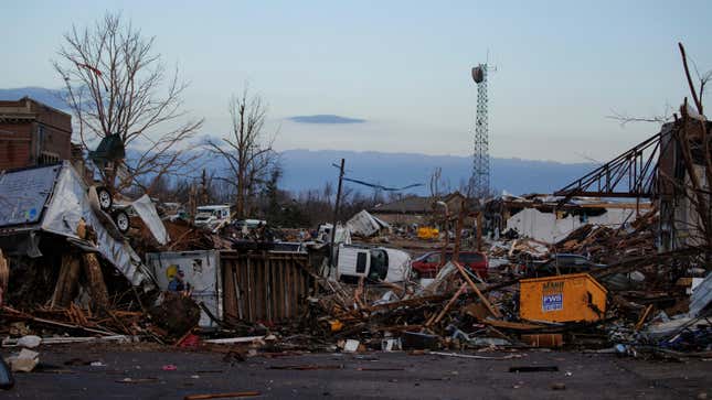
“Everything around us, as much as we could see, is completely destroyed,” Chris Jackson, a storm chaser who tracked the storms as they rolled from Arkansas to Kentucky on Friday, told the Washington Post. “This is without a doubt the worst [tornado] I have ever [seen], and I have been chasing storms for seven years.”
Catastrophic Damage Runs from Arkansas to Illinois
First responders across the six states hit by tornadoes have been busy. Search and rescue operations are ongoing at the aforementioned Amazon warehouse in Edwardsville, Illinois, and nursing home in Monette, Arkansas, where at least one has died.
“It’s just a lot of devastation that we have not seen in my years of working in emergency services,” Bob Blankenship, Monette’s mayor, told CNN.
But police, firefighters, and EMTs have fanned out across the region. A candle factory in Mayfield, Kentucky, is currently a major search and rescue site. There were 110 people trapped when the factory caved in, and Kentucky Gov. Andy Beshear estimated it would be a mass casualty site. Stormchaser Michael Gordon, who is on the scene, told CNN that Mayfield “looked like a war zone.” Drone video at daybreak shows the town almost completely in ruins while photos show slabs where houses once stood and debris wrapped around shattered trees. First responders themselves were impacted, with Mayfield’s firefighters having to dig their way out of their own firehouse.
“I’d be surprised if we don’t see at least five or more” counties with deaths, Beshear said at a news conference. On Saturday morning, he estimated there could be more than 100 dead, which would make this Kentucky’s deadliest tornado.
Blankenship said Monette is without power. That’s also true for more than 300,000 households in states hit by the tornadoes and another roughly 100,000 in other parts of the Midwest.
A Record-Setting Tornado Caused Much of the Damage
Multiple tornadoes touched down on Friday night amid the severe weather outbreak. But one twister, which has been dubbed the “quad-state tornado,” caused most of the damage—and it could be a record-setting tornado.
The tornado tore across a 240-mile (386-kilometer) stretch that included both Monette to Mayfield. Storm investigators with the National Weather Service will look to see if it remained on the ground the whole time. If it did, it would be the longest tornado track ever recorded in the U.S.
Beyond the long track, the violent storm launched debris miles into the sky and far from the tornado’s direct path. A resident of New Albany, Indiana, reported a photo showing up Dawson Springs, Kentucky, a town hit hard by the tornado. The distance as the crow flies between those two locations is roughly 125 miles (200 kilometers).
While official ratings are forthcoming, Beshear said this was the “most severe tornado event in Kentucky’s history.” The NWS investigators will do a formal analysis to officially rate the tornadoes, but radar data captured on Friday night shows that the storm could have been an EF-4 on the Enhanced Fujita Scale and images on the ground bear it out as well. That would make it a “violent” tornado and place its winds between 166 and 200 mph (267 and 322 kph). There have only been three December EF-4 tornadoes in U.S. history.
Bizarre Weather Set the Stage for the Tornado Outbreak
Tornadoes require atmospheric instability to form. In the U.S., that usually means cold fronts ushering in storms from the West and warm, humid air rising up from the Gulf of Mexico. That provides both the energy needed for violent winds to whip up and enough wind shear to cause storms to twist as the front heading east intersects with the Gulf air moving north. While tornadoes can form in any month, winter is usually a relatively quieter period because air over the Gulf isn’t warm enough to provide the necessary fuel.
But the Gulf has maintained warmth and sent it streaming up to the eastern U.S., right as a powerful cold front that brought heavy snow to Colorado swooped out of the West. To give a sense of the opposing temperatures on either side of the front, it was 80 degrees Fahrenheit (27 degrees Celsius) in Memphis and 30 degrees Fahrenheit (minus-1 degree Celsius) in Minneapolis. These clashing masses of air unleashed the historic outbreak of storms.

In addition to tornadoes, the storm system also lit up the skies with lightning and sent hail raining down. Data from Vaisala, a meteorology company, detected more than 782,000 bolts of lightning, making this a rare event by that measure as well. Vaisala meteorologist Chris Vagasky tweeted this ranks as one of the 10 largest December lightning outbreaks since at least 2015.
The Climate Conditions Behind the Severe Weather
A few climate factors are likely at play as well. This fall, La Niña formed. The natural climate pattern in the tropical Pacific can rearrange weather globally, including increasing the odds of more winter twisters in the exact region that saw an outbreak Friday night.
The exact influence climate change is having on tornadoes is hard to pin down, though research does indicate large clusters of twisters are becoming more common. It’s a very active area of research, though.
But as with anything tied to extreme heat, it’s impossible to talk about it without talking about the influence of burning fossil fuels. The rise in the global average temperature means freak heat has become both more common and severe. We’ve seen it time and time again to the point where it’s impossible to talk about abnormal warmth without mentioning climate change. The warm air currently flooding the South will push north and will bring spring-like conditions to the Northeast next week.
This is a developing story and will be updated.