The first hurricane of the season to hit the Northeast is slated to make landfall this weekend. What’s currently Tropical Storm Henri is building up a head of steam over the Atlantic halfway between Florida and Bermuda.
The storm will climb the Eastern Seaboard before slamming into the Northeast likely somewhere between Long Island and Cape Cod on Sunday afternoon or evening. Hurricane and tropical storm watches are already up from New York to Massachusetts, and Henri will make life pretty miserable for anyone in its path. It will also further stretch disaster response resources, with North Carolina still reeling from the damage former Tropical Storm Fred did to the state by unleashing catastrophic flooding.
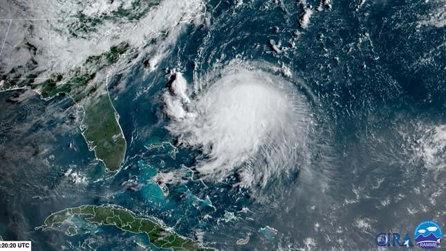
Tropical Storm Henri Is Strengthening
Henri is currently a hefty tropical storm with winds of 65 mph (105 kph). But it’s expected to keep beefing up over the coming days as it cruises over abnormally warm water. Ocean temperatures in Henri’s path are around 82 degrees Fahrenheit (28 degrees Celsius), running up to 3.6 degrees Fahrenheit (2 degrees Celsius) hotter than normal for this time of year. (Need I remind you, climate change is bumping up heat everywhere.)
That will let Henri pick up steam and attain hurricane status sometime on Saturday afternoon. Its winds are forecast to peak at around 86 mph (139 kph)—solidly in the Category 1 range—though it will likely weaken slightly at landfall. Its wind field is also expected to grow, which will allow Henri to push more storm surge ashore.
Henri Will Make Landfall on Sunday
Over the next 48 or so hours, forecasters will continue refining the track of Henri. But models used to inform the forecast have shifted Henri westward over the past 36 or so hours.
As of Friday morning, the National Hurricane Center’s cone of probability has Henri making landfall on Sunday in the late afternoon or evening anywhere from Long Island to Cape Cod (there’s also still a slight chance it’ll steer clear of the landfall entirely). Rhode Island is at the center of the cone. Where Henri makes landfall will matter for storm surge in particular, and where it pushes the most water ashore. Areas to the northeast of the storm’s center will also contend with Henri’s fiercest winds. As of now, those locations include Boston, Providence, Rhode Island, and the Cape.
But regardless of Henri’s exact landfall location, the impacts will be widespread. The NHC forecast shows tropical-storm-force winds are likely from New Jersey to Maine. Rain will also spread across much of that region. The NHC is calling for “2 to 5 inches [5 to 13 centimeters] over southern New England Sunday into Monday, with isolated maximum totals near 8 inches [20 centimeters].” That raises the risks of flooding, particularly in parts of southern New England, which have seen above-average rainfall this summer and have soils that can’t handle much more rain. Adding even more worry is that Henri appears to be slowing down. That will allow rain bands to linger, making the prospect of flooding even worse. It also means the flood risk will extend far inland from where the storm makes landfall.
Storm surge, too, will likely be widespread. The NHC forecast calls for storm surge as far from Henri’s center as Cape May, New Jersey, located at the mouth of the Delaware River in the southern edge of the state. With the current likeliest track for Henri, the worst storm surge will hit Rhode Island, the south side of Cape Cod, Nantucket, and Martha’s Vineyard where up to 5 feet (1.5 meters) of water could rush ashore. Locations as far west as the Rockaways in New York could see up to 4 feet (1.2 meters) of surge, and similar totals could be pushed through parts of Long Island Sound. The wending waterways and bays of Rhode Island could also help funnel storm surge, compounding impacts.
Storm surge watches also include parts of New York, and flooding could affect the city’s airports that sit right on Jamaica Bay and sandwiched between Flushing Bay and the East River respectively.
Connecticut’s largest utility, Eversource, has said that half of its 1.2 million customers could see power outages that last up to 10 days. Massachusetts Gov. Charlie Baker said the state is expecting 100,000 to 300,000 outages as well. The widespread nature of Henri’s impacts means if you’re in the Northeast, pay attention to the forecast.
Recovery Is Still Ongoing From Fred
Henri comes ashore as another part of the U.S. is still reeling from another tropical storm. Former Tropical Storm Fred dumped up to 10 inches (25 centimeters) of rain in western North Carolina, unleashing floods across the region’s mountains and waterways. At least 2 are dead and 20 remain missing in the wake of the floods.
County Emergency Services Director Travis Donaldson said on Thursday that the town of Cruso, about a 30-minute drive southwest of Asheville, “saw some of the worst destruction in Haywood County that I’ve seen in my life.” Recovery there also comes as the West is reeling from brutal wildfires, reflecting a growing risk of disaster fatigue for first responders and disaster volunteers.
We’re Entering the Heart of Hurricane Season
Atlantic hurricane peaks in September, which means the impacts of Fred and Henri could just be a warmup for more serious storms to come. The NHC called for an active hurricane season, and that’s held true so far. Henri is the eighth named storm, several of which have made landfall. That includes Hurricane Grace, which is en route to its third landfall in Mexico after striking the country’s Yucatan Peninsula and Haiti earlier this week.
Hurricane seasons are now more active than they used to be, owing to both climate change and better observations. This year’s season could get an extra late-season boost due to La Niña, a cooling of waters in the eastern tropical Pacific that rearranges the atmosphere around the world. That includes weakening the winds over the Atlantic, Caribbean, and Gulf of Mexico that can impede cyclones from spinning up and strengthening. In other words, hold onto your hats.
Update, 3:45 p.m., 8/20/21: This post has been updated with the latest forecast and power outage information.