

After expanding and contracting in various VR initiatives, Google continues to be committed to AR. It sees the technology more aligned with the future of search. If search and AR had a baby, it would be visual search — Google’s prevailing AR play, otherwise known as Google Lens.
As examined in our Location Wars series, this also takes form in what we call Google’s Internet of Places. This involves indexing the physical world in ways that are analogous to the ways that it built up tremendous value by indexing the web. This is Google’s version of an AR cloud.
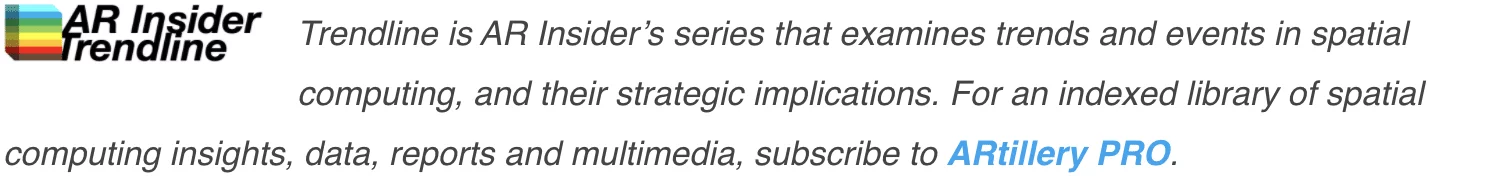
All of this took an evolutionary step this week with new Google Maps updates. The most attention-grabbing of these updates is the expansion of its Live View AR navigation feature to indoor use. This should unlock new use cases such as wayfinding in malls and airports.
The other updates are less directly related to AR — at least AR’s strict definition. These updates involve additional “layers” of context and content that augment any mapping or navigational experiences. In that broader sense, these are AR — or at least AR-adjacent — updates.
Let’s tackle theses new features one at a time…
Live View Goes Indoors
As noted, Google is bringing its visual navigation feature, Live View, indoors. For those unfamiliar, Live View lets users navigate urban areas by holding up their phone and following 3D walking directions. The same functionality is now available in malls in select cities.
As further background, Live View uses Street View imagery to enable AR devices to “localize.” This is the secret sauce that makes its navigational overlays show up in the right places. In the new indoor version, it will similarly use imagery and spatial maps of these locations.
“Thanks to new advancements that help us understand the precise altitude and placement of objects inside a building, we’re now able to bring Live View to some of the trickiest-to-navigate places indoors: airports, transit stations and malls,” Google wrote in a blog post yesterday.
Use cases will develop including finding individual stores or even products. The latter will involve additional data such as store inventory. But like the above moving parts that make Live View possible, Google has that data through GMB and other emerging efforts like Pointy.
Curbside Pickup
Given the pandemic-induced rise of curbside pickup and order-ahead local commerce, Google is now integrating the functionality more directly into Maps. Specifically, it will display shopping info and curbside-pickup availability for stores that appear in Maps and search.
The integration also happens through sharing order info from a store’s app to Google Maps. This means that shoppers can navigate to a store and see all their pickup order details without leaving Google Maps. It will even suggest when you should leave your house to get there on time.
On the store-end, retailers will also get this data. Starting with a trial at Fred Myer supermarkets in Portland Oregon, they’ll know your estimated ETA, so they can time their order preparation accordingly. And when you arrive, they’ll be alerted to bring the order out to your car.

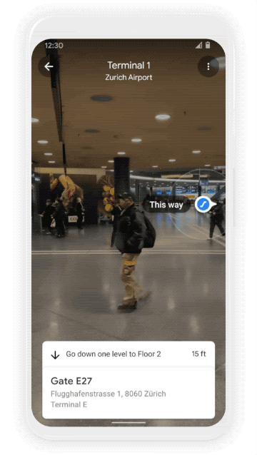
Weather and Eco Layers
Another Google Maps update involves weather. Through data integration with the Weather Company and other sources, users can see current and forecasted temperatures directly in Google Maps. This includes air quality indexes that track allergy, smog, and fire conditions.
Google Maps will also feature a new routing model that optimizes for fuel consumption. It will be based on factors like road incline and traffic conditions. It will default to the route with the lowest carbon footprint if it has approximately the same ETA as the fastest route.
A related new feature will display low-emission zones in countries where they apply. And it will automatically show users the mode of transportation that applies to their situation (think: driving, walking, biking, public transit). This will be based on geographic and behavioral factors.
Pattern Recognition.
When looking at these updates, there’s a pattern: deeper data integration. In some cases, Google is applying its own data while other cases involve partners. In all cases, it works towards a more intelligent and visually-infused Google Maps, thus augmenting mapping as we know it.
As for the most directly AR-related update above, indoor Live View will go live this week on Android and iOS in select malls in select cities, followed by a wider rollout to other regions and location types. Eventually, it plans to expand beyond malls to airports and transit stations.